
MIDTOWN OPA
CONCEPTS
INFORMATION
& HISTORY
OF THE
MIDTOWN OFFICIAL PLAN AMENDMENT PROCESS
TO DATE
Below is a detailed timeline of the actions, studies, meetings and reports regarding the Midtown Official Plan Amendment (OPA) .
October 2025
Ward 3 Councillors Urge Minister to Match OPA and TOC
On Wednesday, September 24th, Minister of Municipal Affairs and Housing of Ontario, Rob Flack visited Oakville to present a 13.2 Million Dollar cheque to Oakville for meeting and exceeding its housing targets for 2024.
Ward 3 Councillors Haslett-Theall and Gittings took advantage of the opportunity to provide a letter to Minister Flack advocating for:
-
the passing of the Midtown Official Plan Amendment 70, which currently lingers with the Ministry AND
-
strongly encourage the Province to ensure the TOC comply with the same planning tenets.

September 2025
Midtown OPA - Update
Following its approval by Oakville Council earlier this year, Oakville's Midtown Official Plan Amendment (OPA 70) was sent to the Province for review and approval.
One necessary step in the process is the posting of the OPA on the Province's Environmental Registry, which is an online tool used by the government to consult people on things such as acts, regulations, policies, etc. including amendments to Municipal Official Plans, such as the Midtown OPA.
While on the registry, the general public and others, such as developers, legal professionals, etc. have the opportunity to comment and voice opposition or support for a proposed OPA. The comment period for the Midtown OPA closed on June 29, 2025. Currently, we await approval by Minister of Municipal Affairs and Housing, Robert Flack.
While the Ministry has received comments, these have not been made public and will not be until a decision is made by the Minister.
It is important to ensure residents understand that the Minister has the power to amend, delete or change various policies in the Midtown Official Plan Amendment as submitted. Any changes made by the Minister are final and are not subject to appeal. The Minister's decision will outline what was requested, and what was either accepted or amended.
At this time, it is our sense a decision by the Minister is imminent and may include modifications to our submission as outlined above. Updates will be published as soon as they become available.
April 2025
Midtown OPA - Council Approval & Next Steps
On Tuesday Feb 18 Oakville's Planning & Development Council unanimously supported a responsible, though bold, Official Plan Amendment for Midtown that is the result of considerable thought and evaluation by planners, market analysts, economists, lawyers, engineers and the public.
The Midtown plan is balanced, defensible and, with a collaborative approach by all, has the potential to deliver a vibrant, livable neighbourhood. Thank you to everyone who stood up for the future livability of Oakville.
If you missed the Feb 18th. meeting of Council, you can watch the meeting and hear the delegations presented by the public. Council comments start at 1:23.
Here are key comments we made.
Does this OPA achieve all that some desired? No ... because let’s be honest it will be a lot of people. The OPA is the upper limit of what the severely constrained area of Midtown can handle. Yet it is the result of considerable thoughtful evaluation by planners, markets analysts, economists. lawyers, engineers and the public. It is balanced, defensible and with a collaborative approach by all has potential to be vibrant livable neighbourhood.
This OPA takes us to a far better place than we were 2 years ago. ( Yes!) It carries forward an important principle from our current OP that an exchange of benefits must occur if a developer is to exceed our height limit. It’s a responsible, balanced approach to optimizing the developable land available.
There is significant work ahead on key studies such as the Transportation Plan, the public realm and urban design plan, Community Permit Planning and more. Our goal is for a community that will thrive not just survive.
Next Steps
As is the requirement under Provincial Legislation, the OPA has been submitted for approval by the Minister of Municipal Affairs and Housing. We have advocated that this be done swiftly.
As well, we now have a new Minister and Oakville Staff have a list of studies that must be completed which will involve more public input and Council approval. These include the Midtown Transportation Plan, the Urban design and Public Realm plan, the Community Permit Planning bylaw and Green Energy Standards. Shaping the vision continues!
In that light, On March 27th a Midtown Public Information Meeting (PIM) was held to share and gather feedback on implementation work for Midtown’s Stormwater, Transportation, Public Realm and Urban Design.
See the Information Boards Used During the PIM.
Additional opportunities for public engagement and input are being planned for June 2025. Please remain active and engaged.
Monday, January 20, 2025 @6:30 p.m.
Midtown OPA - Statutory Public Meeting
The proposed Midtown OPA is available for you to read and is posted on the Oakville.ca website.
It has new language based on earlier feedback but there is still room for improvement in the language to achieve a great new neighbourhood.
That means you are strongly encouraged to continue to contribute to the quality of the Official Plan amendment on January 20, 2025 at Council. You can attend either in-person or virtually and provide input at this meeting. Learn more about delegating here.
It's important to continue to be involved and provide feedback, because after the meeting on January 20, it will move to a decision in February and once approved that is the PLAN ( except for the 5 hectares governed by the TOC).
The documents included with the October meeting below STILL play an important role in Midtown's future. The Growth Analysis Report by Watson and the Midtown Market Feasibility Report by N. Barry Lyon provide facts and details on Midtown's future capability and capacity as one of Oakville's growth areas. Take time to read and understand them.
October 29, 2024
Special Meeting of Council - Draft OPA
On Oct 29, delegations were heard at a Special Council meeting to provide comments and input on the NEW Official Plan amendment for Midtown.
A full list of documents available for review are below with links
-
A Growth Analysis Report by Watson & Associates Economists Ltc.
-
Copies of Correspondence and Comments Received on the Draft OPA
The mood was cautiously optimistic and it was acknowledged that progress is being made.
In response to the Staff Presentation the public continues to ask many questions that must be addressed as Council work towards a final OPA in January 2025. These include:
-
Who/how will the Town pay for the significant cost of infrastructure? Do we have an accurate projection of those costs? Is it 450k or 700k (see slide 10) and what will be covered by Development Charges?
-
Will this OPA enable us to achieve the necessary parkland we all know is needed for a livable neighbourhood? How much play and green space will we actually achieve?
-
Will the proposed maximum densities and policies ensure bordering communities are not living in shadows?
-
Will the proposed Transportation Plan actually work given the volume of people using the GO station in this already congested corridor?
-
At what point will Metrolinx recognize the need to be part of the solution by providing an East platform to support transit use at second busiest station in their network?
-
Will the Community Permit Planning System (CPPS) and this OPA ensure that Council retains control over the scale and massing providing important benefits without sacrificing livability?
-
Council needs to implement a Green Development Standards bylaw, which together with a Community Permit Planning system will require sustainable development.
-
The significance of ensuring long term protection from increasing significant rain events.
-
Council and residents require clarity on the calculations that determined the projected build out population density.
-
The forecast reports identify market issues that must be considered, including that the 'end user' whether it be a renter or owner needs a home not a 500 or 600 sq. ft box. (See reports listed above)
-
What can be done to mitigate against the trend of failing development projects?
-
The phasing of Midtown risks being an island unless there is a coordinated plan landowners agree to.
-
How will inclusionary zoning be incorporated into Midtown.
A very strong message was expressed by delegations requesting Mayor Burton’s leadership in stopping the TOC.
Dates for the Town's OPA Public Open House in Nov/Dec will be announced shortly. Please Stay Tuned!
The September 2024 Version of The Draft OPA For Midtown
Staff has prepared its latest draft OPA for Midtown.
You can view it here online . Or, if you prefer, you can see it here as a pdf document.
New to this OPA is the introduction of a Community Planning Permit System (CPPS), a tool which has several uses including the ability for a developer to achieve additional building height in return for community benefits such as parkland, affordable housing units or a cash contribution the Town would use toward other community benefits.
Also of note:
-
a revised population/density figure for Midtown. This draft has been based on planning for 29,900 residents and jobs combined by 2051.
-
a revised FSI schedule with maximum FSI of 6
Staff have created a Highlights Area of what they see as
being notable points in the new draft.
Click on the image to view.

The October 10 Council Workshop
On Wed Oct 10, Council participated in a workshop to learn more about the NEW draft OPA.
The draft OPA has several positive changes including a reduction from the prior OPA on the forecasted population, consistency from the original Official Plan on base heights of 12-20 and that any additional height or gross floor area will require the provision of community benefits. A key change is there is a proposed limit or maximum density for each area of Midtown above the 'as of right heights' in the previous Official Plan.
The OPA will enable the use of a of a new Planning Tool: a Community Planning Permit System which will have its own bylaw. CPPS supports the needed benefits for a complete community by requiring a developer who may want to achieve the greater height or maximum floor space index/height to provide community benefits. Simply stated CPPS replaces bonusing while streamlining the process and giving all stakeholders greater clarity on community benefits. There will be lots of discussion and public engagement as this new bylaw is developed in 2025.
Council members had several questions of staff which you can view here. It was a long meeting, but you are encouraged to view it, as it will help you to build a better understanding of information moving forward.
What's Next?
November 2024 - a Public Information meeting will be scheduled. Stay Tuned!
Previously Proposed Concept
Below are several elements drawn from the concept as proposed by staff and consultants. They highlight aspects such as building heights, green space, transportation, etc.
The two meetings can be viewed online here as one video
Proposed Concept: By Precinct

Draft Height Ranges

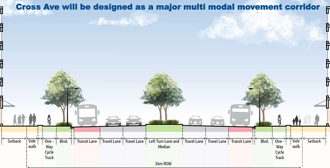
Proposed Concept: Trafalgar Road/Cross Avenue Gateway

Proposed Density by Area (FSI)

Proposed Green Space, Possible Schools

An Alternate View of Density
One presentation from residents was of particular interest, as it provided examples of how density works on a plot of land - using a 1ha example. For those in the audience and viewing at home it was a clear and simple demonstration of how various forms of buildings can use the same piece of land, thereby creating increased density.
Many of Oakville's residents associations had made the request in past that the public be given concepts that reflected different levels of density using buildings other than tall towers. This presentation helped to communicate how Midtown development could be approached in a manner that includes staggered building heights.

A cluster of buildings at different heights.
The same building cluster from street view

View the Presentation Slides

Watch the Segment on Video

January 2024 Presentation
Here is the presentation slide deck from the January 30th meeting. It is long and extensive, but worth your time to review.

November 2023 Consultant's Concepts
These concepts have similar population and density (approx 60k people and 19k jobs.) They vary in terms of where different uses would be allowed and the distribution of density. The majority of the buildings would be mixed use: commercial and office on the lower levels and residential above.
Concepts are purely conceptual. We would need to purchase or negotiate to acquire certain pieces of parkland.


Sample Development Applications
A sample of current development applications for Midtown. Additional information on other applications as well as details are available at the Oakville.ca website.
349 Davis Road
(east of Trafalgar)
Corbett Land Strategies
Proposed 58 Storey Mixed Use Building
388 residential units

